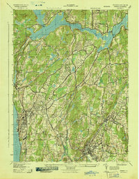
1943 Map of Ossining
USGS Topo · Published 1943About this map
Sing Sing State Prison stands as a prominent landmark on the banks of the Hudson River in this 1943 survey of Westchester County. The landscape is defined by the massive Croton Reservoir to the north and a network of growing suburban settlements connected by the New York Central railroad and the Putnam Division. Educational and religious institutions are numerous, including the Mary Knoll Convent, Briarcliff Junior College, and the Friends Meeting House near Chappaqua. The map illustrates a transitional era where large estates and social clubs like the Sleepy Hollow Country Club and Chilmark Club coexist with concentrated village centers. Local history is preserved in the naming of several crossroads, such as Van Tassells Corners and Buckhouts Corners, while the State Game Refuge occupies a significant tract of interior woodland.
Find a feature on this map
90 named features on this map. Tap any name to fly to it.
Don’t see what you’re looking for? This feature index may not catch every label — zoom into the map to look around manually.
Map Details
Editions of this 1943 Ossining Map
4 editions found
Other maps of this area

1892 · Stamford
USGS Topo · 1:62,500

1892 · West Point
USGS Topo · 1:62,500

1892 · Carmel
USGS Topo · 1:62,500

1892 · Tarrytown
USGS Topo · 1:62,500

1893 · Carmel
USGS Topo · 1:62,500

1893 · Stamford
USGS Topo · 1:62,500

1893 · Tarrytown
USGS Topo · 1:62,500

1894 · West Point
USGS Topo · 1:62,500

1894 · Carmel
USGS Topo · 1:62,500

1899 · Stamford
USGS Topo · 1:62,500