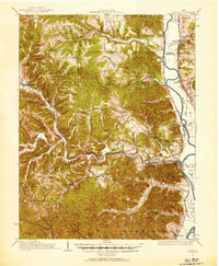
1915 Map of Otway
USGS Topo · Published 1963About this map
Scioto Brush Creek and the winding Scioto River define this deeply dissected landscape in southern Ohio during the early twentieth century. The settlement of Otway serves as a central hub where the Norfolk and Western Railway navigates the narrow valley floor, following the water's path toward Rarden and Arion. The map reveals a high density of rural schoolhouses, including Starr School, Pine Flat School, and McBride School, reflecting the scattered but organized community structure typical of the era's upland farms. Along the eastern edge, the Baltimore and Ohio Railroad and Chesapeake and Ohio Railway parallel the river, connecting riverside towns like Wakefield and Clifford. The intricate contouring highlights prominent elevations such as Bear Creek Knob and Campbell Hill, showing how early transportation and housing were strictly dictated by the complex ridgelines and stream valleys of the McChesney Ridge area.
Find a feature on this map
97 named features on this map. Tap any name to fly to it.
Don’t see what you’re looking for? This feature index may not catch every label — zoom into the map to look around manually.
Map Details
Editions of this 1915 Otway Map
2 editions found
Other maps of this area

1906 · Waverly
USGS Topo · 1:62,500

1908 · Waverly
USGS Topo · 1:62,500

1911 · Sciotoville
USGS Topo · 1:62,500

1913 · Sciotoville
USGS Topo · 1:62,500

1915 · Bainbridge
USGS Topo · 1:48,000

1915 · Garrison
USGS Topo · 1:62,500

1915 · Otway
USGS Topo · 1:62,500

1915 · Piketon
USGS Topo · 1:62,500

1916 · Peebles
USGS Topo · 1:62,500

1917 · Bainbridge
USGS Topo · 1:62,500