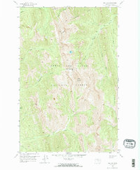
1958 Map of Our Lake
USGS Topo · Published 1967About this map
Lewis and Clark National Forest dominates this mountain landscape, which was documented by the Geological Survey during a mid-century field check. The area is defined by the high elevations of Rocky Mountain and Old Baldy, where the drainage network forms the headwaters of the South Fork Teton River and Middle Fk Teton River. The presence of Beartop Lookout indicates the importance of fire observation in this backcountry during the 1950s. Navigating the steep terrain relied on established paths like the Pack Trail connecting Route Creek Pass and Headquarters Creek Pass. Small alpine water bodies, most notably Our Lake, sit within deep basins carved between Lonesome Ridge and the various forks of the Teton. This survey provides a precise look at the wilderness geography before more modern forest management practices altered the trail systems and lookouts of Teton County.
Find a feature on this map
24 named features on this map. Tap any name to fly to it.
Don’t see what you’re looking for? This feature index may not catch every label — zoom into the map to look around manually.
Map Details
Editions of this 1958 Our Lake Map
Other maps of this area

1903 · Saypo
USGS Topo · 1:125,000

1955 · Choteau
USGS Topo · 1:250,000

1957 · Choteau
USGS Topo · 1:250,000

1958 · Choteau
USGS Topo · 1:250,000

1958 · Ear Mountain
USGS Topo · 1:24,000

1958 · Cave Mountain
USGS Topo · 1:24,000

1958 · Porphyry Reef
USGS Topo · 1:24,000

1958 · Mount Wright
USGS Topo · 1:24,000

1958 · Our Lake
USGS Topo · 1:24,000

1958 · Glenn Creek
USGS Topo · 1:24,000