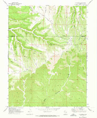
1970 Map of P R Spring
USGS Topo · Published 1973About this map
The high plateau of the East Book Cliffs along the Uintah and Grand County line is defined by deeply incised drainage systems like Main Canyon and Black Horse Canyon. At this 1970 snapshot, the landscape reflects a transitional economy where remote ranching at Tomlinson Ranch coexists with industrial expansion. Significant energy development is visible across the southern half of the sheet, marked by the Gas Field and the Westwater Gas Field. Evidence of this specialized infrastructure is scattered throughout the canyons and ridges in the form of several Drill Holes and a prominent Pipeline. Transportation in this complex terrain relied on a network of Pack Trails and Jeep Trails, with a remote Landing Strip providing essential access to the high ground near Seep Canyon. Local landmarks like P R Spring and Pope Well highlight the importance of water sources in this arid upland environment.
Find a feature on this map
36 named features on this map. Tap any name to fly to it.
Don’t see what you’re looking for? This feature index may not catch every label — zoom into the map to look around manually.
Map Details
Editions of this 1970 P R Spring Map
2 editions found
Other maps of this area

1885 · East Tavaputs
USGS Topo · 1:250,000

1956 · Grand Junction
USGS Topo · 1:250,000

1959 · Grand Junction
USGS Topo · 1:250,000

1960 · Grand Junction
USGS Topo · 1:250,000

1962 · Grand Junction
USGS Topo · 1:250,000

1964 · Grand Junction
USGS Topo · 1:250,000

1965 · Grand Junction
USGS Topo · 1:250,000

1966 · Seep Canyon
USGS Topo · 1:24,000

1966 · Tom Patterson Canyon
USGS Topo · 1:24,000
1966 · Pine Spring Canyon
USGS Topo · 1:24,000