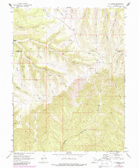
1970 Map of P R Spring
USGS Topo · Published 1987About this map
Tomlinson Ranch stands as a lonely outpost on the high plateau along the border of Uintah and Grand counties. This 1970s landscape is defined by the high, flat-topped Horse Ridge, Seep Ridge, and Poge Ridge, which separate a complex network of deep drainages like Main Canyon and Black Horse Canyon. The presence of a remote Landing Strip and multiple drill holes indicates the region's mid-century shift toward energy exploration, formalizing into the Horse Point Gas Field and Westwater Gas Field. Evidence of earlier land use survives in the form of several corrals and a Pack Trail that once served the livestock operations centering on P R Spring. The map captures a moment when traditional ranching infrastructure began to coexist with a sprawling industrial Pipeline network.
Find a feature on this map
37 named features on this map. Tap any name to fly to it.
Don’t see what you’re looking for? This feature index may not catch every label — zoom into the map to look around manually.
Map Details
Editions of this 1970 P R Spring Map
2 editions found
Other maps of this area

1885 · East Tavaputs
USGS Topo · 1:250,000

1956 · Grand Junction
USGS Topo · 1:250,000

1959 · Grand Junction
USGS Topo · 1:250,000

1960 · Grand Junction
USGS Topo · 1:250,000

1962 · Grand Junction
USGS Topo · 1:250,000

1964 · Grand Junction
USGS Topo · 1:250,000

1965 · Grand Junction
USGS Topo · 1:250,000

1966 · Seep Canyon
USGS Topo · 1:24,000

1966 · Tom Patterson Canyon
USGS Topo · 1:24,000
1966 · Pine Spring Canyon
USGS Topo · 1:24,000