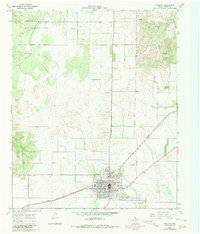
1967 Map of Paducah
USGS Topo · Published 1981About this map
Paducah serves as the focal point of this West Texas landscape, situated at the intersection of critical regional transit routes. The Quanah Acme and Pacific railroad cuts a diagonal path through the territory, a vestige of the era's rail-dependent economy. To the northwest, the Matador Wildlife Management Area occupies a significant portion of the terrain, defined by the drainage of O X Creek and Shorty Creek. This 1967 survey, with revisions from 1979, illustrates a community balanced between its cattle-country roots and mid-century infrastructure. Within the town limits, local landmarks such as the Garden of Memories (Cem) and the Dan Richards Municipal Airport are clearly delineated, alongside more modern developments like the Golf Course and a prominent Radio Tower. Numerous gravel pits scattered across the central section point to the area's local extraction industries during this period.
Find a feature on this map
13 named features on this map. Tap any name to fly to it.
Don’t see what you’re looking for? This feature index may not catch every label — zoom into the map to look around manually.
Map Details
Editions of this 1967 Paducah Map
2 editions found
Other maps of this area

1954 · Lubbock
USGS Topo · 1:250,000

1954 · Plainview
USGS Topo · 1:250,000

1958 · Plainview
USGS Topo · 1:250,000

1966 · Cee Vee
USGS Topo · 1:24,000

1966 · Devils Canyon
USGS Topo · 1:24,000

1967 · Dunlap
USGS Topo · 1:24,000

1967 · Paducah
USGS Topo · 1:24,000

1967 · Moons Camp
USGS Topo · 1:24,000
1967 · Swearingen
USGS Topo · 1:24,000
1968 · Chalk
USGS Topo · 1:24,000