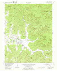
1954 Map of Pall Mall
USGS Topo · Published 1979About this map
The Alvin York Highway serves as the central artery for this mid-century portrait of the Tennessee-Kentucky borderlands, winding past the community of Pall Mall. This area, deeply tied to the history of World War I hero Alvin C. York, is characterized by its network of rural institutions like the York Bible Sch, York Chapel, and Wolf River Ch. The landscape is a complex system of ridges and hollows, where the Wolf River and its tributaries, such as the Rotten Fork Wolf River, have carved deep into the terrain.
Find a feature on this map
74 named features on this map. Tap any name to fly to it.
Don’t see what you’re looking for? This feature index may not catch every label — zoom into the map to look around manually.
Map Details
Editions of this 1954 Pall Mall Map
4 editions found
Other maps of this area

1895 · Wartburg
USGS Topo · 1:125,000

1896 · Wartburg
USGS Topo · 1:125,000

1897 · Standingstone
USGS Topo · 1:125,000

1898 · Standingstone
USGS Topo · 1:125,000

1929 · Byrdstown
USGS Topo · 1:62,500

1934 · Pall Mall
USGS Topo · 1:62,500

1954 · Stockton
USGS Topo · 1:24,000

1954 · Parmleysville
USGS Topo · 1:24,000

1954 · Jamestown
USGS Topo · 1:24,000

1954 · Savage
USGS Topo · 1:24,000