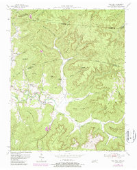
1954 Map of Pall Mall
USGS Topo · Published 1986About this map
Pall Mall and the surrounding borderlands of Fentress and Pickett Counties are defined by the winding course of the Wolf River and its numerous tributaries. This mid-century landscape reflects a deeply rooted community connected by the Alvin C York Highway, named for the local World War I hero. The map reveals a dense network of local institutions, including York Chapel, York Bible Sch, and Frogge Chapel, which served the scattered farmsteads of the valley. Settlement patterns follow the bottomlands and gaps between prominent ridges like Goodman Ridge and Wayne Trace Ridge. Moving east toward Black House Mountain, the terrain becomes more isolated, transitioning into the Cumberland National Forest. Genealogists will find significant value in the documented family-named landmarks and small burial grounds such as Wolf River Cem, which anchor the local history of the Wolf River valley during this period.
Find a feature on this map
63 named features on this map. Tap any name to fly to it.
Don’t see what you’re looking for? This feature index may not catch every label — zoom into the map to look around manually.
Map Details
Editions of this 1954 Pall Mall Map
4 editions found
Other maps of this area

1895 · Wartburg
USGS Topo · 1:125,000

1896 · Wartburg
USGS Topo · 1:125,000

1897 · Standingstone
USGS Topo · 1:125,000

1898 · Standingstone
USGS Topo · 1:125,000

1929 · Byrdstown
USGS Topo · 1:62,500

1934 · Pall Mall
USGS Topo · 1:62,500

1954 · Stockton
USGS Topo · 1:24,000

1954 · Parmleysville
USGS Topo · 1:24,000

1954 · Jamestown
USGS Topo · 1:24,000

1954 · Savage
USGS Topo · 1:24,000