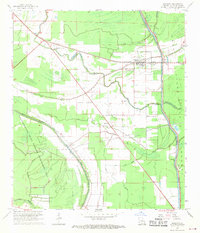
1968 Map of Palmetto
USGS Topo · Published 1970About this map
The low-lying bayous and agricultural lands of northern St. Landry Parish are defined here by the Atchafalaya Floodway and the intricate drainage of Bayou Petite Prairie and Fish Bayou. The settlement of Palmetto serves as a local hub along the Texas and Pacific railroad, supported by surrounding communities like Rideau Settlement and Lebeau. This 1960s survey documents a landscape balancing heavy industry, seen in the sprawling Oil and Gas Field and its accompanying Pipelines, with conservation in the Thistlethwaite State Wildlife Management Area. Numerous small country churches, including Sacred Heart Ch and St James Ch, alongside the McBride Cem and Goudeau Cem, provide a detailed look at the social and genealogical fabric of these rural Louisiana townships before modern consolidation.
Find a feature on this map
43 named features on this map. Tap any name to fly to it.
Don’t see what you’re looking for? This feature index may not catch every label — zoom into the map to look around manually.
Map Details
Editions of this 1968 Palmetto Map
3 editions found
Other maps of this area

1939 · Opelousas
USGS Topo · 1:62,500

1948 · Bunkie
USGS Topo · 1:62,500

1952 · Lake Charles
USGS Topo · 1:250,000

1954 · Lake Charles
USGS Topo · 1:250,000

1954 · Baton Rouge
USGS Topo · 1:250,000

1955 · Odenburg
USGS Topo · 1:62,500

1956 · Opelousas
USGS Topo · 1:62,500

1956 · Baton Rouge
USGS Topo · 1:250,000

1957 · Opelousas
USGS Topo · 1:62,500

1959 · Palmetto
USGS Topo · 1:62,500