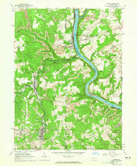
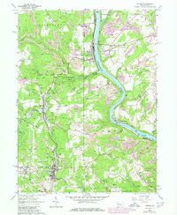
1963 Map of Parker
USGS Topo · Published 1965About this map
The Allegheny River and Clarion River converge in this northern Pennsylvania industrial corridor during the early 1960s, a landscape defined by the deep incisions of the North Branch and South Branch of Bear Creek. The region’s economic foundation is visible in the dense concentration of oil and gas wells peppering the plateaus above the river valleys. The town of Parker sits at a strategic bend, while to the south and west, the smaller boroughs of Bruin, Petrolia, and Karns City align with the Baltimore and Ohio railroad line. Local history is deeply embedded in the rural outskirts, where several family and community landmarks like Bear Creek Cemetery, Fletcher Cem, and Robinson Memorial Chapel sit amidst the winding ridge roads. Small island features such as Clarion Island and Black Fox Island break the flow of the rivers, marking key points along the river navigation miles.
Find a feature on this map
50 named features on this map. Tap any name to fly to it.
Don’t see what you’re looking for? This feature index may not catch every label — zoom into the map to look around manually.
Map Details
Editions of this 1963 Parker Map
5 editions found
Other maps of this area

1900 · Kittanning
USGS Topo · 1:62,500

1902 · Kittanning
USGS Topo · 1:62,500

1907 · Foxburg
USGS Topo · 1:62,500

1908 · Foxburg
USGS Topo · 1:62,500

1909 · Butler
USGS Topo · 1:62,500

1910 · Hilliards
USGS Topo · 1:62,500

1911 · Butler
USGS Topo · 1:62,500

1912 · Hilliards
USGS Topo · 1:62,500

1944 · Hilliards
USGS Topo · 1:62,500

1953 · Pittsburgh
USGS Topo · 1:250,000