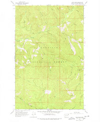
1967 Map of Pass Creek
USGS Topo · Published 1978About this map
Colville National Forest and Kaniksu National Forest converge in this 1967 survey of the Selkirk Mountains region. The landscape is defined by the high elevations of Hall Mountain and Grassy Top Mtn, where numerous drainage systems such as Sullivan Creek and Harvey Creek carve through the steep terrain. Evidence of wilderness occupation and utility is found in the Last Chance Cabin and an isolated Mine located near Totem Creek, indicating the persistent mineral interests and seasonal forestry work in this corner of the state.
Find a feature on this map
40 named features on this map. Tap any name to fly to it.
Don’t see what you’re looking for? This feature index may not catch every label — zoom into the map to look around manually.
Map Details
Editions of this 1967 Pass Creek Map
3 editions found

Other maps of this area

1934 · Metaline
USGS Topo · 1:125,000

1942 · Metaline
USGS Topo · 1:125,000

1958 · Sandpoint
USGS Topo · 1:250,000

1963 · Sandpoint
USGS Topo · 1:250,000

1967 · Gypsy Peak
USGS Topo · 1:24,000

1967 · Scotchman Lake
USGS Topo · 1:24,000

1967 · Boundary Dam
USGS Topo · 1:24,000

1967 · Salmo Mtn.
USGS Topo · 1:24,000

1967 · Metaline Falls
USGS Topo · 1:24,000

1967 · Monumental Mtn.
USGS Topo · 1:24,000