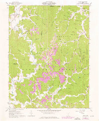
1961 Map of Pedro
USGS Topo · Published 1976About this map
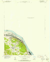
Buckhorn Furnace and Lawrence Furnace stand as industrial reminders of the charcoal iron era within the wooded hills of Wayne National Forest. The landscape is deeply carved by water, with a dense network of hollows such as Germany Hollow and Charred Hollow surrounding the mining and transit corridors. The Detroit Toledo and Ironton RR follows the path of Pine Creek, connecting local hubs like Superior and Pedro. Local life in the mid-20th century is anchored by neighborhood landmarks like Mt Hope Ch, Pedro Sch, and numerous family cemeteries including Collins Cem and Vernon Cem. The presence of several Strip Mines and Quarries, some linked by a conveyor system, highlights the region's continued reliance on the extraction of clay and coal from the Lawrence County ridges.
Find a feature on this map
83 named features on this map. Tap any name to fly to it.
Don’t see what you’re looking for? This feature index may not catch every label — zoom into the map to look around manually.
Map Details
Editions of this 1961 Pedro Map
4 editions found
Other maps of this area

1898 · Ironton
USGS Topo · 1:62,500

1900 · Ironton
USGS Topo · 1:62,500

1911 · Sciotoville
USGS Topo · 1:62,500

1912 · Oak Hill
USGS Topo · 1:62,500

1913 · Sciotoville
USGS Topo · 1:62,500

1926 · Greenup
USGS Topo · 1:48,000

1930 · Greenup
USGS Topo · 1:62,500

1953 · Greenup
USGS Topo · 1:24,000
1953 · Ironton
USGS Topo · 1:24,000

1957 · Huntington
USGS Topo · 1:250,000