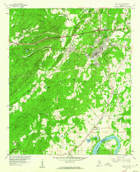
1958 Map of Pell City
USGS Topo · Published 1960About this map
Pell City stands as the central hub of this late-1950s landscape, positioned where the Southern Railway meets a developing network of highways. The map reveals a transition from industrial and textile-related settlements like Avondale Village and Crestview Gardens to the outlying agricultural and rural communities. In the southern reach, the Coosa River defines the landscape at Griffitt Bend, just before the major hydro-electric changes that would alter the river's path. Local social foundations are well-documented through numerous country schools and churches, including the Greenfield School and Mt Hillery Crossroads Church. The inclusion of small residential pockets like Harrisburg, Eden, and Walkerton reflects the early suburban-industrial layout of St. Clair County before modern expansion merged many of these distinct locales.
Find a feature on this map
63 named features on this map. Tap any name to fly to it.
Don’t see what you’re looking for? This feature index may not catch every label — zoom into the map to look around manually.
Map Details
Editions of this 1958 Pell City Map
4 editions found
Other maps of this area

1889 · Springville
USGS Topo · 1:125,000

1890 · Talladega
USGS Topo · 1:125,000

1892 · Springville
USGS Topo · 1:125,000

1892 · Talladega
USGS Topo · 1:125,000

1943 · Talladega
USGS Topo · 1:62,500

1946 · Talladega
USGS Topo · 1:62,500

1947 · Ragland
USGS Topo · 1:62,500

1947 · Ragland
USGS Topo · 1:24,000

1947 · Riverside
USGS Topo · 1:24,000

1951 · Vincent
USGS Topo · 1:24,000