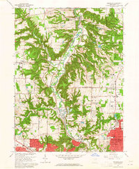
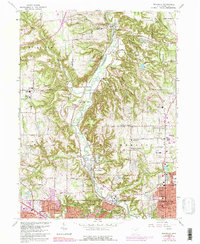
1963 Map of Peninsula
USGS Topo · Published 1965About this map
The Cuyahoga River carves a deep valley through this portion of the Connecticut Western Reserve, anchoring a landscape where industrial infrastructure and recreational space exist side-by-side. The Baltimore and Ohio railroad tracks trace the river's winding course, serving the hamlets of Peninsula, Everett, and Ira. In the southern reaches, the transition from rural townships like Northampton to the urban fringes of Akron and Cuyahoga Falls is marked by the presence of large municipal facilities such as the Akron Sewage Disposal plant and the Police Rifle Range and Dog Training Area.
Find a feature on this map
76 named features on this map. Tap any name to fly to it.
Don’t see what you’re looking for? This feature index may not catch every label — zoom into the map to look around manually.
Map Details
Editions of this 1963 Peninsula Map
5 editions found
Other maps of this area

1903 · Cleveland
USGS Topo · 1:62,500

1903 · Akron
USGS Topo · 1:62,500

1905 · Akron
USGS Topo · 1:62,500

1906 · Kent
USGS Topo · 1:62,500

1906 · Chagrin Falls
USGS Topo · 1:62,500

1908 · Chagrin Falls
USGS Topo · 1:62,500

1950 · Cleveland
USGS Topo · 1:250,000

1953 · Broadview Heights
USGS Topo · 1:24,000

1953 · Twinsburg
USGS Topo · 1:24,000
1953 · Northfield
USGS Topo · 1:24,000