
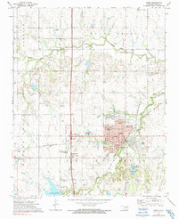
1972 Map of Perry
USGS Topo · Published 1974About this map
The Oklahoma plains of the early 1970s center on the city of Perry, where the local economy and culture are anchored by the Noble County Courthouse and the Cherokee Strip Museum. This survey captures the intersection of two major rail lines, the St Louis - San Francisco and the Atchison Topeka and Santa Fe, which shaped the town's growth along the banks of Black Bear Creek.
Find a feature on this map
39 named features on this map. Tap any name to fly to it.
Don’t see what you’re looking for? This feature index may not catch every label — zoom into the map to look around manually.
Map Details
Editions of this 1972 Perry Map
2 editions found
Other maps of this area

1893 · Mulhall
USGS Topo · 1:62,500

1893 · Stillwater
USGS Topo · 1:62,500

1955 · Enid
USGS Topo · 1:250,000

1958 · Enid
USGS Topo · 1:250,000

1966 · Lake Carl Blackwell
USGS Topo · 1:24,000

1972 · Perry NW
USGS Topo · 1:24,000

1972 · Red Rock
USGS Topo · 1:24,000

1972 · Ceres
USGS Topo · 1:24,000

1972 · Lucien
USGS Topo · 1:24,000
1972 · Black Bear
USGS Topo · 1:24,000