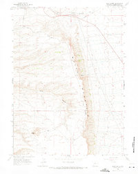
1961 Map of Pilot Butte
USGS Topo · Published 1971About this map
White Mountain dominates this high desert landscape of Sweetwater County, rising above the surrounding plains north of the Rock Springs area. This 1961 survey illustrates a region shaped by overland travel and ranching, anchored by the Fourteenmile Ranch near the banks of Fourteenmile Creek. The map documents early transit routes through the Wyoming sagebrush, including the Chiltons Cutoff and the rugged White Mountain Road. To the south, the prominent landmark of Pilot Butte serves as a distinct navigational beacon for the region. The drainage patterns of Scott Canyon and various unnamed Springs highlight the scarce but critical water sources that dictated the location of early settlements and livestock operations in this arid environment during the mid-twentieth century.
Find a feature on this map
10 named features on this map. Tap any name to fly to it.
Don’t see what you’re looking for? This feature index may not catch every label — zoom into the map to look around manually.
Map Details
Editions of this 1961 Pilot Butte Map
3 editions found
Other maps of this area

1908 · Rock Springs
USGS Topo · 1:62,500

1910 · Rock Springs
USGS Topo · 1:62,500

1954 · Rock Springs
USGS Topo · 1:250,000

1958 · Rock Springs
USGS Topo · 1:250,000

1958 · Boars Tusk
USGS Topo · 1:62,500

1961 · Scott Spring
USGS Topo · 1:24,000

1961 · Pilot Butte
USGS Topo · 1:24,000

1961 · Kanda
USGS Topo · 1:24,000

1961 · Green River
USGS Topo · 1:24,000

1962 · Rock Springs
USGS Topo · 1:250,000