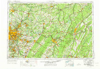
1958 Map of Pittsburgh
USGS Topo · Published 1975About this map
Industrial centers and river valleys anchor the landscape of Western Pennsylvania in this late-1960s revision. The confluence of the Allegheny River and Monongahela River marks the core of Pittsburgh, while the Youghiogheny River and Kiskiminetas River serve as arteries for coal and steel towns like Mc Keesport, Vandergrift, and Ford City. The map documents a mature transportation network where the Pennsylvania RR and Baltimore and Ohio RR parallel historic corridors like the Lincoln Highway and the Pennsylvania Turnpike.
Find a feature on this map
100 named features on this map. Tap any name to fly to it.
Don’t see what you’re looking for? This feature index may not catch every label — zoom into the map to look around manually.
Map Details
Editions of this 1958 Pittsburgh Map
5 editions found

Other maps of this area

1900 · Uniontown
USGS Topo · 1:62,500

1900 · Mercersburg
USGS Topo · 1:62,500

1900 · Masontown
USGS Topo · 1:62,500

1900 · Latrobe
USGS Topo · 1:62,500

1900 · Everett
USGS Topo · 1:62,500

1900 · Kittanning
USGS Topo · 1:62,500

1901 · Amity
USGS Topo · 1:62,500

1901 · Rural Valley
USGS Topo · 1:62,500

1901 · Waynesburg
USGS Topo · 1:62,500

1901 · Huntingdon
USGS Topo · 1:62,500