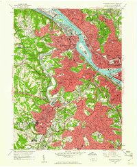
1960 Map of Pittsburgh West
USGS Topo · Published 1961About this map
The Ohio River industrial corridor and the rugged hills of western Allegheny County are captured here at a moment of mid-century maturity. Major institutional landmarks anchor the landscape, from the riverside Western State Penitentiary and Allegheny General Hospital to the sprawl of the Woodville State Hospital further south. The convergence of the Allegheny River and Monongahela River marks the eastern edge of the survey, where Point State Park stands as a focal point of urban renewal.
Find a feature on this map
160 named features on this map. Tap any name to fly to it.
Don’t see what you’re looking for? This feature index may not catch every label — zoom into the map to look around manually.
Map Details
Editions of this 1960 Pittsburgh West Map
4 editions found
Other maps of this area

1904 · Mc Keesport
USGS Topo · 1:62,500

1904 · Carnegie
USGS Topo · 1:62,500

1906 · Carnegie
USGS Topo · 1:62,500

1906 · Sewickley
USGS Topo · 1:62,500

1907 · Pittsburg
USGS Topo · 1:62,500

1908 · Sewickley
USGS Topo · 1:62,500

1908 · Carnegie
USGS Topo · 1:62,500

1908 · New Kensington
USGS Topo · 1:62,500

1910 · New Kensington
USGS Topo · 1:62,500

1948 · Pittsburgh West
USGS Topo · 1:24,000