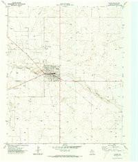
1971 Map of Plains
USGS Topo · Published 1973About this map
Plains serves as the focal point for this Yoakum County survey, positioned at the junction of regional thoroughfares like Old Lovington Road. The landscape is defined by the extensive energy infrastructure of the High Plains, characterized by the sprawling Plains Oil Field and the Brahaney Oil Field. A dense network of drill holes and oil wells punctuates the terrain, revealing the intensity of petroleum extraction in West Texas during the early 1970s.
Find a feature on this map
14 named features on this map. Tap any name to fly to it.
Don’t see what you’re looking for? This feature index may not catch every label — zoom into the map to look around manually.
Map Details
Editions of this 1971 Plains Map
This is the sole edition of this map. No revisions or reprints were ever made.
Other maps of this area

1954 · Brownfield
USGS Topo · 1:250,000

1958 · Brownfield
USGS Topo · 1:250,000

1962 · Brownfield
USGS Topo · 1:250,000

1970 · Plains 1 SW
USGS Topo · 1:24,000

1970 · Tokio NW
USGS Topo · 1:24,000

1970 · Pleasant Hill
USGS Topo · 1:24,000

1971 · Plains NW
USGS Topo · 1:24,000
1971 · Ink Basin
USGS Topo · 1:24,000
1971 · Plains SE
USGS Topo · 1:24,000
1971 · Two B Ranch
USGS Topo · 1:24,000