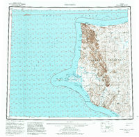
1955 Map of Point Hope
USGS Topo · Published 1983About this map
Point Hope juts into the Chukchi Sea at the western edge of the Lisburne Peninsula, anchoring a landscape defined by indigenous maritime heritage and early industrial ventures. This mid-century survey records the concentration of settlement along the spit, including the traditional village of Tigara and the nearby locale of Jabbertown. The coastal geography is marked by several named habitation sites such as Kukpuk and Ogsachak, which suggest historical seasonal use and ancestral locations along the Kukpuk River and the northern shorelines.
Find a feature on this map
72 named features on this map. Tap any name to fly to it.
Don’t see what you’re looking for? This feature index may not catch every label — zoom into the map to look around manually.
Map Details
Editions of this 1955 Point Hope Map
3 editions found

Other maps of this area

1951 · De Long Mountains
USGS Topo · 1:250,000

1951 · Noatak
USGS Topo · 1:250,000

1951 · Point Lay
USGS Topo · 1:250,000

1952 · Point Hope
USGS Topo · 1:250,000
1952 · Noatak D-7
USGS Topo · 1:63,360

1952 · Point Hope A-2
USGS Topo · 1:63,360

1952 · Point Hope B-3
USGS Topo · 1:63,360
1952 · Point Hope C-3
USGS Topo · 1:63,360

1952 · Point Hope D-1
USGS Topo · 1:63,360

1952 · Point Hope D-2
USGS Topo · 1:63,360