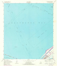
1954 Map of Port Bolivar
USGS Topo · Published 1977About this map
The waters of Galveston Bay dominate this mid-century survey, revealing the critical maritime infrastructure connecting the Texas coast. The settlement of Port Bolivar sits at the tip of the Bolivar Peninsula, serving as a vital juncture for the Intracoastal Waterway and the Houston Ship Channel. This 1954 field-checked data, with later 1970s photogrammetric revisions, highlights the constant shifting of the coastal landscape, from the extensive Hanna Reef to the tidal flats near Hanna.
Find a feature on this map
30 named features on this map. Tap any name to fly to it.
Don’t see what you’re looking for? This feature index may not catch every label — zoom into the map to look around manually.
Map Details
Editions of this 1954 Port Bolivar Map
4 editions found
Other maps of this area

1929 · Virginia Point
USGS Topo · 1:24,000

1929 · Texas City
USGS Topo · 1:24,000

1930 · Galveston
USGS Topo · 1:24,000

1931 · Flake
USGS Topo · 1:24,000

1932 · Clifton By The Sea
USGS Topo · 1:31,680

1932 · Texas City
USGS Topo · 1:31,680

1932 · Bolivar Point
USGS Topo · 1:24,000

1932 · Virginia Point
USGS Topo · 1:31,680

1933 · The Jetties
USGS Topo · 1:31,680

1933 · Whites Lake
USGS Topo · 1:31,680