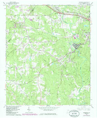
1964 Map of Porterdale
USGS Topo · Published 1985About this map
The Yellow River anchors this landscape, flowing through the industrial and residential heart of Porterdale and past the outskirts of Covington. By the mid-1960s, the area shows a clear transition from rural agriculture to expanding suburban development, particularly evident near the Seaboard Coast Line railroad and the Central of Georgia tracks. Historical social centers like the Salem Campground and the Livingston Sch reflect the long-standing community structure of Newton County. Further south, the river transitions into more natural features such as Langston Shoals and Cedar Shoals. Rural life is marked by numerous family and community landmarks, including Peeks Chapel, Richards Chapel, and Hopewell Ch, while newer additions like the Golf Course near the northern border signal the encroachment of modern recreation. The presence of Lawnwood Memorial Park and various smaller cemeteries like Shiloh Cem provide valuable touchpoints for local genealogical research.
Find a feature on this map
53 named features on this map. Tap any name to fly to it.
Don’t see what you’re looking for? This feature index may not catch every label — zoom into the map to look around manually.
Map Details
Editions of this 1964 Porterdale Map
4 editions found

Other maps of this area

1888 · Atlanta
USGS Topo · 1:125,000

1890 · Atlanta
USGS Topo · 1:125,000

1892 · Atlanta
USGS Topo · 1:125,000

1895 · Atlanta
USGS Topo · 1:125,000

1896 · Monroe
USGS Topo · 1:125,000

1953 · Atlanta
USGS Topo · 1:250,000

1953 · Athens
USGS Topo · 1:250,000

1956 · Conyers
USGS Topo · 1:24,000

1957 · Atlanta
USGS Topo · 1:250,000

1958 · Athens
USGS Topo · 1:250,000