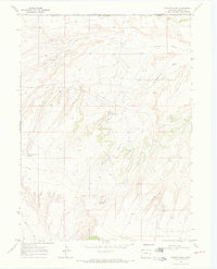
1969 Map of Powder Wash
USGS Topo · Published 1973About this map
Powder Wash Oil and Gas Field defines the industrial footprint of this high-desert landscape on the border of Colorado and Wyoming. Industrial infrastructure is peppered throughout the terrain, marked by numerous Oil Wells, a network of pipelines, and a Pumping Sta. The topography is deeply incised by drainages with colorful local names like Ace in the Hole Draw and Eagle Rock Draw, while the Beaver Slide terrain feature drops toward the north. Water sources are critical points in this arid environment, represented by West Dripping Rock Spring and Dans Hole Spring. This 1969 field-checked survey illustrates the mid-century development of natural resources in Moffat County, showing how access roads and industrial sites were integrated into a landscape shaped by the Powder Wash and its North Fork.
Find a feature on this map
19 named features on this map. Tap any name to fly to it.
Don’t see what you’re looking for? This feature index may not catch every label — zoom into the map to look around manually.
Map Details
Editions of this 1969 Powder Wash Map
3 editions found

Other maps of this area

1954 · Vernal
USGS Topo · 1:250,000

1954 · Rock Springs
USGS Topo · 1:250,000

1958 · Vernal
USGS Topo · 1:250,000

1958 · Rock Springs
USGS Topo · 1:250,000

1960 · Vernal
USGS Topo · 1:250,000

1962 · Rock Springs
USGS Topo · 1:250,000

1969 · Reservoir Draw
USGS Topo · 1:24,000

1969 · The Nipple
USGS Topo · 1:24,000

1969 · Sheepherder Springs
USGS Topo · 1:24,000

1969 · Coffeepot Spring
USGS Topo · 1:24,000