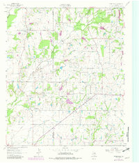
1962 Map of Prairieville
USGS Topo · Published 1982About this map
Prairieville sits at the heart of a landscape defined by the winding tributaries of the Lacy Fork, where small rural communities and family-centered landmarks predominated in the early 1960s. This survey, updated with 1970s woodland revisions, captures the agrarian character of the Kaufman and Van Zandt County boundary. The area is dotted with local institutions like Prairieville Ch, Elm Grove Ch, and the White Hall Community Center, alongside several generational burial grounds such as Aanonsen Cem and Board Cem. The terrain is shaped by a dense network of waterways including Caney Creek, Dry Creek, and Knudson Branch, which weave between small settlements like Roddy and Odom. These features reflect a traditional East Texas settlement pattern of small, creek-aligned farms and community-specific social hubs that persisted even as infrastructure slowly modernized.
Find a feature on this map
21 named features on this map. Tap any name to fly to it.
Don’t see what you’re looking for? This feature index may not catch every label — zoom into the map to look around manually.
Map Details
Editions of this 1962 Prairieville Map
2 editions found

Other maps of this area

1920 · Kemp
USGS Topo · 1:62,500

1948 · Martins Mill
USGS Topo · 1:62,500

1949 · Martins Mill
USGS Topo · 1:62,500

1954 · Dallas
USGS Topo · 1:250,000

1956 · Tyler
USGS Topo · 1:250,000

1957 · Kemp
USGS Topo · 1:62,500

1958 · Dallas
USGS Topo · 1:250,000

1960 · Tool
USGS Topo · 1:24,000

1960 · Mabank
USGS Topo · 1:24,000

1961 · Kemp
USGS Topo · 1:24,000