Loading...
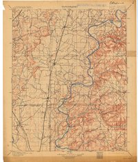
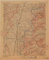
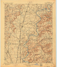
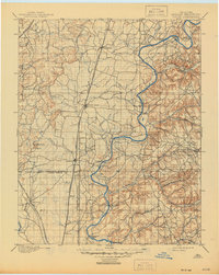
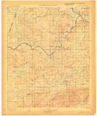
Loading map...1901 Map of Pryor
USGS Topo · Published 1913About this map
The Neosho River snakes through the heart of the Cherokee Nation in this survey of northeastern Oklahoma, conducted just before the turn of the century. The landscape is defined by an intricate network of river crossings, including Markham Ferry, Sixkiller Ferry, and Adams Ford, which served as vital transit points before modern bridging. The central corridor is dominated by the Missouri Kansas and Texas R. R., connecting early rail stops like Adair and Pryor Creek.
Find a feature on this map
45 named features on this map. Tap any name to fly to it.
Don’t see what you’re looking for? This feature index may not catch every label — zoom into the map to look around manually.
Map Details
Date Portrayed1901
Date Published1913
PublisherU.S. Geological Survey
Map TypeTopographic
Scale1:125,000
Physical Dimensions17.1 x 20 inches
Editions of this 1901 Pryor Map
5 editions found

Historical Maps of Claremore Through Time

Featured Locations
Source Details
SourceU.S. Geological Survey
CopyrightPublic Domain