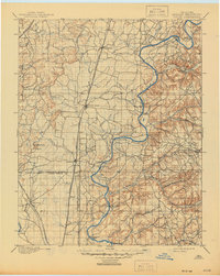
1901 Map of Pryor
USGS Topo · Published 1945About this map
The Neosho River serves as the central artery of this Oklahoma landscape, recorded when the region was still organized as the Cherokee Nation and Creek Nation. In the late nineteenth century, the river had not yet been dammed, and its crossing points were vital to local commerce and travel. A remarkable network of ferries, including Markham Ferry, Sixkiller Ferry, and Poindexter Ferry, provided passage across the water before modern bridges became commonplace.
Find a feature on this map
53 named features on this map. Tap any name to fly to it.
Don’t see what you’re looking for? This feature index may not catch every label — zoom into the map to look around manually.
Map Details
Editions of this 1901 Pryor Map
5 editions found
Other maps of this area

1896 · Okmulgee
USGS Topo · 1:125,000

1896 · Pryor
USGS Topo · 1:125,000

1898 · Tahlequah
USGS Topo · 1:125,000

1899 · Siloam Springs
USGS Topo · 1:125,000

1900 · Okmulgee
USGS Topo · 1:125,000

1901 · Muscogee
USGS Topo · 1:125,000

1901 · Claremore
USGS Topo · 1:125,000

1901 · Nowata
USGS Topo · 1:125,000

1901 · Vinita
USGS Topo · 1:125,000

1901 · Pryor
USGS Topo · 1:125,000