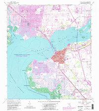
1957 Map of Punta Gorda
USGS Topo · Published 1988About this map
Punta Gorda sits at the convergence of the Peace River and Charlotte Harbor, showing a landscape defined by significant late-20th-century residential growth. This survey, updated with late-1980s data, reveals the extensive canal systems of Punta Gorda Isles and the development of Port Charlotte north of the river. The historic grid of the city center is contrasted by the expanding suburbs of Solana, Charlotte Park, and Harbour Heights. Infrastructure for the region's transport is well-documented, from the Barron Collier Bridge spanning the river to the CSX rail line and the County Airport. Local life and heritage are represented by landmarks such as the Charlotte High Sch, the Indian Springs Cem near Acline, and the Municipal Dock. The map also captures the natural margins of the harbor, including Mangrove Point and the Gasparilla Sound-Charlotte Harbor State Aquatic Preserve.
Find a feature on this map
35 named features on this map. Tap any name to fly to it.
Don’t see what you’re looking for? This feature index may not catch every label — zoom into the map to look around manually.
Map Details
Editions of this 1957 Punta Gorda Map
5 editions found

Other maps of this area

1956 · Murdock
USGS Topo · 1:24,000

1956 · Murdock SE
USGS Topo · 1:24,000

1956 · Cleveland
USGS Topo · 1:24,000

1956 · Ft. Ogden
USGS Topo · 1:24,000

1956 · Punta Gorda SE
USGS Topo · 1:24,000

1956 · West Palm Beach
USGS Topo · 1:250,000

1956 · Tampa
USGS Topo · 1:250,000

1956 · Fort Pierce
USGS Topo · 1:250,000

1956 · Charlotte Harbor
USGS Topo · 1:250,000

1957 · West Palm Beach
USGS Topo · 1:250,000