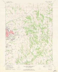
1971 Map of Quincy East
USGS Topo · Published 1973About this map
The eastern expansion of Quincy dominates the western edge of this 1971 survey, showing a landscape in transition where suburban growth meets the rural townships of Ellington and Melrose. The city's edge is marked by civic and religious institutions, including the National Cemetery, St Peters Ch, and the Chaddock Boys Sch. Beyond the built-up grid of Broadway and Maine St, the terrain softens into the drainage basins of Curtis Creek and Mill Creek, where family-named burial grounds like Voorhees Cem, Kemp Cem, and Laughlin Cem sit among active farmsteads. To the east, smaller settlements like Burton and Ewbanks remain distinct, connected by the Burlington railroad line. The map captures the era's infrastructure with numerous communications assets, such as the Radio Tower (KHQA-TV) and the private Halfpap Landing Strip near the southern boundary.
Find a feature on this map
60 named features on this map. Tap any name to fly to it.
Don’t see what you’re looking for? This feature index may not catch every label — zoom into the map to look around manually.
Map Details
Editions of this 1971 Quincy East Map
2 editions found
Other maps of this area

1925 · Quincy
USGS Topo · 1:62,500

1925 · Liberty
USGS Topo · 1:62,500

1927 · Liberty
USGS Topo · 1:62,500

1944 · Quincy
USGS Topo · 1:62,500

1945 · Quincy
USGS Topo · 1:62,500

1946 · Mendon
USGS Topo · 1:62,500

1948 · Quincy
USGS Topo · 1:250,000

1948 · Mendon
USGS Topo · 1:62,500

1948 · Camp Point
USGS Topo · 1:62,500

1956 · Quincy
USGS Topo · 1:250,000