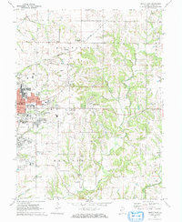
1971 Map of Quincy East
USGS Topo · Published 1973About this map
The city of Quincy dominates the western edge of this 1971 survey, showing a transition from dense urban development to the agricultural landscapes of Ellington and Melrose townships. Genealogy researchers will find significant value in the high concentration of burial sites, ranging from the National Cem and St Peters Cem near the city center to smaller family and church-affiliated plots like the Laughlin Cem, Eeds Cem, and Melrose Chapel Cem.
Find a feature on this map
62 named features on this map. Tap any name to fly to it.
Don’t see what you’re looking for? This feature index may not catch every label — zoom into the map to look around manually.
Map Details
Editions of this 1971 Quincy East Map
2 editions found
Other maps of this area

1925 · Quincy
USGS Topo · 1:62,500

1925 · Liberty
USGS Topo · 1:62,500

1927 · Liberty
USGS Topo · 1:62,500

1944 · Quincy
USGS Topo · 1:62,500

1945 · Quincy
USGS Topo · 1:62,500

1946 · Mendon
USGS Topo · 1:62,500

1948 · Quincy
USGS Topo · 1:250,000

1948 · Mendon
USGS Topo · 1:62,500

1948 · Camp Point
USGS Topo · 1:62,500

1956 · Quincy
USGS Topo · 1:250,000