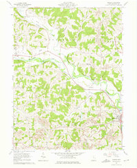
1962 Map of Randle
USGS Topo · Published 1975About this map
The confluence of the Walhonding River and the Tuscarawas River anchors this 1960s study of Coshocton County. The landscape is defined by the remnants of 19th-century infrastructure, notably an old railroad grade and a segment of the old canal tracing the valley floors. These corridors sit in contrast to the extensive strip mines that mark the higher elevations of Pinfeather Ridge and the surrounding townships. Local life is documented through scattered rural centers like Metham and Warsaw, alongside family and community landmarks such as Antioch Cem, Prairie Chapel, and the House of Jacob Tabernacle. Significant river engineering is visible at Sixmile Dam and the Roscoe Basin, illustrating the importance of water management to this industrial and agricultural region.
Find a feature on this map
47 named features on this map. Tap any name to fly to it.
Don’t see what you’re looking for? This feature index may not catch every label — zoom into the map to look around manually.
Map Details
Editions of this 1962 Randle Map
4 editions found
Other maps of this area

1908 · Conesville
USGS Topo · 1:62,500

1910 · Frazeysburg
USGS Topo · 1:62,500

1910 · Conesville
USGS Topo · 1:62,500

1913 · Brinkhaven
USGS Topo · 1:62,500

1913 · Coshocton
USGS Topo · 1:62,500

1915 · Brinkhaven
USGS Topo · 1:62,500

1915 · Coshocton
USGS Topo · 1:62,500

1943 · Coshocton
USGS Topo · 1:62,500

1950 · Marion
USGS Topo · 1:250,000

1951 · Canton
USGS Topo · 1:250,000