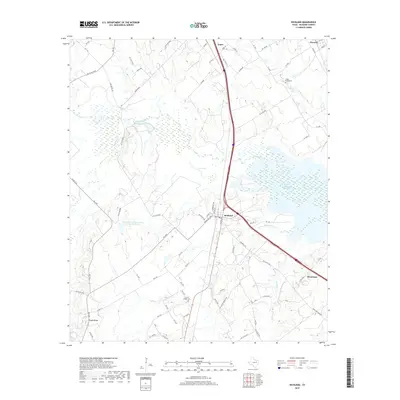
2019 Map of Richland
USGS Topo · Published 2019About this map
Richland and Angus anchor this portion of Navarro County, where the Interstate 45 corridor cuts through a landscape defined by complex water systems and small rural communities. The modern industrial footprint is visible at Texas Industries Lake, a significant body of water that contrasts with natural features like Love Lake and the meandering path of Richland Creek. This area south of Corsicana shows a transition from agricultural fields to managed wetlands and reservoirs, including the Soil Conservation Service Site 36 Reservoir.
Find a feature on this map
78 named features on this map. Tap any name to fly to it.
Don’t see what you’re looking for? This feature index may not catch every label — zoom into the map to look around manually.
Map Details
Editions of this 2019 Richland Map
This is the sole edition of this map. No revisions or reprints were ever made.
Other maps of this area

1954 · Dallas
USGS Topo · 1:250,000

1954 · Waco
USGS Topo · 1:250,000

1955 · Waco
USGS Topo · 1:250,000

1958 · Dallas
USGS Topo · 1:250,000

1959 · Powell
USGS Topo · 1:24,000

1960 · Streetman
USGS Topo · 1:24,000

1963 · Richland
USGS Topo · 1:24,000

1963 · Wortham
USGS Topo · 1:24,000

1963 · Kirvin
USGS Topo · 1:24,000
1965 · Corsicana
USGS Topo · 1:24,000