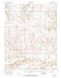
1955 Map of Richland
USGS Topo · Published 1971About this map
The Wakarusa River and the Missouri Pacific railroad corridor anchor the rural landscape of eastern Shawnee County in the mid-1950s. This survey captures a network of small agricultural settlements and community centers like Richland and Watson, connected by a web of unimproved and light-duty roads. The map reveals the distribution of early educational and religious sites, including Williams Sch, Howard Sch, and the notably marked Lyons Sch (Abandoned). Local genealogy is well-supported by several distinct burial grounds such as Zion Cem, Bauer Cem, and Richland Cem. To the northwest, Lake Shawnee sits near the edges of the township, while the winding course of Deer Creek and Lynn Creek define the local drainage patterns. Significant social hubs of the era, such as the Community Hall and Camp Hammond, reflect the civic and recreational life of the Monmouth area before later development altered the river valley.
Find a feature on this map
24 named features on this map. Tap any name to fly to it.
Don’t see what you’re looking for? This feature index may not catch every label — zoom into the map to look around manually.
Map Details
Editions of this 1955 Richland Map
3 editions found
Other maps of this area

1885 · Lawrence
USGS Topo · 1:125,000

1886 · Oskaloosa
USGS Topo · 1:125,000

1888 · Oskaloosa
USGS Topo · 1:125,000

1889 · Burlingame
USGS Topo · 1:125,000

1889 · Topeka
USGS Topo · 1:125,000

1889 · Lawrence
USGS Topo · 1:125,000

1894 · Burlingame
USGS Topo · 1:125,000

1894 · Oskaloosa
USGS Topo · 1:125,000

1894 · Topeka
USGS Topo · 1:125,000

1947 · Lawrence
USGS Topo · 1:250,000