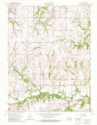
1955 Map of Richland
USGS Topo · Published 1982About this map
The lowlands of Shawnee and Douglas counties unfold across this mid-century landscape, centered on the village of Richland. Located at the intersection of the Missouri Pacific railroad and the Wakarusa River, the settlement serves as a hub for the surrounding agricultural townships of Tecumseh and Monmouth. The landscape is defined by the winding course of the river and several tributaries, including Lynn Creek and Camp Creek, which carve through the terrain before the major reservoir developments of later decades.
Find a feature on this map
23 named features on this map. Tap any name to fly to it.
Don’t see what you’re looking for? This feature index may not catch every label — zoom into the map to look around manually.
Map Details
Editions of this 1955 Richland Map
3 editions found
Other maps of this area

1885 · Lawrence
USGS Topo · 1:125,000

1886 · Oskaloosa
USGS Topo · 1:125,000

1888 · Oskaloosa
USGS Topo · 1:125,000

1889 · Burlingame
USGS Topo · 1:125,000

1889 · Topeka
USGS Topo · 1:125,000

1889 · Lawrence
USGS Topo · 1:125,000

1894 · Burlingame
USGS Topo · 1:125,000

1894 · Oskaloosa
USGS Topo · 1:125,000

1894 · Topeka
USGS Topo · 1:125,000

1947 · Lawrence
USGS Topo · 1:250,000