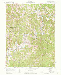
1960 Map of Rinard Mills
USGS Topo · Published 1961About this map
The Little Muskingum River carves a winding path through this corner of the Wayne National Forest, defining a landscape of sharp ridges and narrow hollows. In the early 1960s, the area remained a patchwork of small agricultural settlements and timbered slopes, centered around crossroads like Rinard Mills and Bloomfield. The map reveals a high concentration of community landmarks, including the Muskingum Valley Ch and Point Pleasant Ch, which anchored the social life of rural families in the Ludlow and Independence townships. Transportation at this time relied on a network of ridge-top roads such as Beardmore Road and Wingett Road. This survey captures the transition of the region as it maintained its traditional rural character while the extraction industry began to dot the hillsides with numerous gas wells, a detail of significant value for those researching the industrial and genealogical history of Washington and Monroe counties.
Find a feature on this map
84 named features on this map. Tap any name to fly to it.
Don’t see what you’re looking for? This feature index may not catch every label — zoom into the map to look around manually.
Map Details
Editions of this 1960 Rinard Mills Map
Other maps of this area

1903 · Macksburg
USGS Topo · 1:62,500

1904 · Marietta
USGS Topo · 1:62,500

1905 · New Matamoras
USGS Topo · 1:62,500

1905 · Macksburg
USGS Topo · 1:62,500

1906 · Saint Marys
USGS Topo · 1:62,500

1924 · St Marys
USGS Topo · 1:62,500

1924 · New Matamoras
USGS Topo · 1:62,500

1924 · Marietta
USGS Topo · 1:62,500

1926 · New Matamoras
USGS Topo · 1:62,500

1927 · Marietta
USGS Topo · 1:62,500