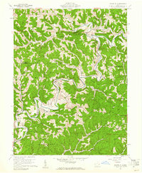
1960 Map of Rinard Mills
USGS Topo · Published 1961About this map
The Little Muskingum River winds through a landscape of sharp ridges and deep hollows in southeastern Ohio, defining the geography of the Wayne National Forest. By the early 1960s, this area maintained a rural character shaped by both agriculture and industry, as evidenced by the numerous gas wells scattered across the uplands. Settlement patterns follow the high ground, with communities like Rinard Mills and Bloomfield situated near the river, while others like Cline and Dye occupy the prominent ridges. The presence of the Muskingum Valley Pumping Sta and a gaging station along the river highlights the importance of water management and energy infrastructure in this portion of Washington and Monroe counties. Genealogists will find significant local history in the distribution of family-named landmarks such as Haney Cem, Hopewell Ch, and Haney Ridge, which reflect the generations of families who settled this territory within the Old Seven Ranges.
Find a feature on this map
68 named features on this map. Tap any name to fly to it.
Don’t see what you’re looking for? This feature index may not catch every label — zoom into the map to look around manually.
Map Details
Editions of this 1960 Rinard Mills Map
Other maps of this area

1903 · Macksburg
USGS Topo · 1:62,500

1904 · Marietta
USGS Topo · 1:62,500

1905 · New Matamoras
USGS Topo · 1:62,500

1905 · Macksburg
USGS Topo · 1:62,500

1906 · Saint Marys
USGS Topo · 1:62,500

1924 · St Marys
USGS Topo · 1:62,500

1924 · New Matamoras
USGS Topo · 1:62,500

1924 · Marietta
USGS Topo · 1:62,500

1926 · New Matamoras
USGS Topo · 1:62,500

1927 · Marietta
USGS Topo · 1:62,500