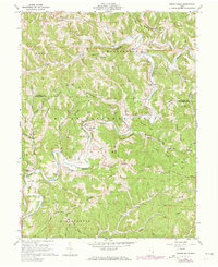
1960 Map of Rinard Mills
USGS Topo · Published 1973About this map
The Little Muskingum River carves a winding path through this corner of southeast Ohio, dictating the settlement patterns and transport routes of the mid-twentieth century. Much of the terrain is defined by steep ridges and narrow runs, with the Wayne National Forest blanketing the central hills. Local life centers on small crossroads and river landings like Rinard Mills, Bloomfield, and Hohman. The landscape is dotted with numerous oil and gas wells, reflecting the region's long-standing extractive industry. Genealogists will find a wealth of specific local landmarks, including several country churches such as Muskingum Valley Ch and Point Pleasant Ch, alongside family-named terrain features like Beardmore Ridge and Hohman Ridge. The presence of a Gaging Station and a Pumping Sta near the river indicates the technical infrastructure required to manage the area's natural resources and water levels during this era.
Find a feature on this map
68 named features on this map. Tap any name to fly to it.
Don’t see what you’re looking for? This feature index may not catch every label — zoom into the map to look around manually.
Map Details
Editions of this 1960 Rinard Mills Map
Other maps of this area

1903 · Macksburg
USGS Topo · 1:62,500

1904 · Marietta
USGS Topo · 1:62,500

1905 · New Matamoras
USGS Topo · 1:62,500

1905 · Macksburg
USGS Topo · 1:62,500

1906 · Saint Marys
USGS Topo · 1:62,500

1924 · St Marys
USGS Topo · 1:62,500

1924 · New Matamoras
USGS Topo · 1:62,500

1924 · Marietta
USGS Topo · 1:62,500

1926 · New Matamoras
USGS Topo · 1:62,500

1927 · Marietta
USGS Topo · 1:62,500