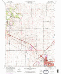
1970 Map of Rising
USGS Topo · Published 1976About this map
The Sangamon River winds through the northwestern corner of this quadrangle, defining a rural landscape of townships like Newcomb and Condit as the urban edge of Champaign begins its northward expansion. Small family and community landmarks such as Oak Grove Cem and Jersey Cem dot the countryside, while the Penn Central railroad tracks cut a diagonal path toward the settlement of Rising. The transition from agriculture to recreation is evident at Lake of the Woods Park, which features managed water bodies and organized greenspace.
Find a feature on this map
36 named features on this map. Tap any name to fly to it.
Don’t see what you’re looking for? This feature index may not catch every label — zoom into the map to look around manually.
Map Details
Editions of this 1970 Rising Map
3 editions found
Other maps of this area

1906 · Urbana
USGS Topo · 1:62,500

1907 · Mahomet
USGS Topo · 1:62,500

1924 · Paxton
USGS Topo · 1:62,500

1927 · Paxton
USGS Topo · 1:62,500

1928 · Gibson City
USGS Topo · 1:62,500

1949 · Paxton
USGS Topo · 1:62,500

1957 · Urbana
USGS Topo · 1:62,500

1957 · Paxton
USGS Topo · 1:62,500

1957 · Gibson City
USGS Topo · 1:62,500

1957 · Urbana
USGS Topo · 1:24,000