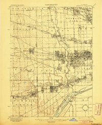
1901 Map of Riverside
USGS Topo · Published 1905About this map
The Desplaines River serves as the central artery for this turn-of-the-century landscape, where the rapidly expanding Chicago City Line meets a dense network of industrial transit. The map documents a critical period of hydrological engineering, showing the Chicago Sanitary and Ship Canal running parallel to the older Illinois and Michigan Canal, with the Ogden Ditch and Ogden Dam visible near Lyons. This intersection of water and rail is further defined by the massive footprint of the Chicago Union Transfer Railroad Yards in the south.
Find a feature on this map
94 named features on this map. Tap any name to fly to it.
Don’t see what you’re looking for? This feature index may not catch every label — zoom into the map to look around manually.
Map Details
Editions of this 1901 Riverside Map
4 editions found

Other maps of this area

1889 · Chicago
USGS Topo · 1:62,500

1890 · Des Plaines
USGS Topo · 1:62,500

1891 · Chicago
USGS Topo · 1:62,500

1891 · Riverside
USGS Topo · 1:62,500

1892 · Joliet
USGS Topo · 1:62,500

1892 · Calumet
USGS Topo · 1:62,500

1893 · Calumet
USGS Topo · 1:62,500

1893 · Riverside
USGS Topo · 1:62,500

1894 · Des Plaines
USGS Topo · 1:62,500

1899 · Evanston
USGS Topo · 1:62,500