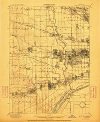
1901 Map of Riverside
USGS Topo · Published 1911About this map
The Desplaines River valley serves as the central artery for this survey, showcasing a landscape in the midst of rapid industrial and suburban transition west of the Chicago City Line. The map reveals the intricate engineering of the era, most notably the Chicago Sanitary and Ship Canal and the Ogden Ditch, which redirected the region's natural hydrology for sanitation and commerce. At Ogden Dam, the intersection of these waterways highlights the massive infrastructure projects that shaped the modern Cook County landscape.
Find a feature on this map
83 named features on this map. Tap any name to fly to it.
Don’t see what you’re looking for? This feature index may not catch every label — zoom into the map to look around manually.
Map Details
Editions of this 1901 Riverside Map
4 editions found

Other maps of this area

1889 · Chicago
USGS Topo · 1:62,500

1890 · Des Plaines
USGS Topo · 1:62,500

1891 · Chicago
USGS Topo · 1:62,500

1891 · Riverside
USGS Topo · 1:62,500

1892 · Joliet
USGS Topo · 1:62,500

1892 · Calumet
USGS Topo · 1:62,500

1893 · Calumet
USGS Topo · 1:62,500

1893 · Riverside
USGS Topo · 1:62,500

1894 · Des Plaines
USGS Topo · 1:62,500

1899 · Evanston
USGS Topo · 1:62,500