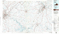
1985 Map of Roanoke
USGS Topo · Published 1986About this map
The Roanoke River corridor serves as the backbone of this 1980s landscape, winding through a complex topography defined by Smith Mountain Lake and Leesville Lake. This era shows the mature development of regional infrastructure, including the Blue Ridge Parkway and major rail lines like the Norfolk and Western and Southern. The map captures the industrial and cultural intersections of Roanoke and Lynchburg, while preserving smaller rural landmarks such as the Booker T Washington National Monument. Smaller communities like Boones Mill, Villamont, and Thaxton are visible along the rail corridors, reflecting the area's growth patterns between the Blue Ridge and the rolling hills of the Piedmont. Significant public lands, including the Jefferson National Forest and Smith Mountain Lake State Park, underscore the region's emphasis on forest conservation and water management.
Find a feature on this map
175 named features on this map. Tap any name to fly to it.
Don’t see what you’re looking for? This feature index may not catch every label — zoom into the map to look around manually.
Map Details
Editions of this 1985 Roanoke Map
2 editions found
Other maps of this area

1887 · Lewisburg
USGS Topo · 1:125,000

1890 · Roanoke
USGS Topo · 1:125,000

1890 · Christiansburg
USGS Topo · 1:125,000

1891 · Roanoke
USGS Topo · 1:125,000

1891 · Lewisburg
USGS Topo · 1:125,000

1892 · Lynchburg
USGS Topo · 1:125,000

1892 · Buckingham
USGS Topo · 1:125,000

1892 · Appomattox
USGS Topo · 1:125,000

1894 · Natural Bridge
USGS Topo · 1:125,000

1894 · Lexington
USGS Topo · 1:125,000