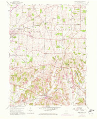
1960 Map of Robertsville
USGS Topo · Published 1972About this map
Louisville and Robertsville anchor this Stark County landscape during a period of transition between traditional farming and industrial extraction. The topography is deeply marked by the extractive economy of the era, visible in the numerous Strip Mine operations and industrial Brickkilns found near the Norfolk and Western railway lines. Local genealogy is well-represented through scattered family-named sites such as Beech Cem, Motts Cem, and the Zwick Cem, alongside small rural institutions like Salem Ch and Township Sch. Waterways including Nimishillen Creek and Sandy Creek cut through the townships of Washington and Osnaburg, while newer leisure developments like Copes Lake and the Edgewater Golf Course suggest the post-war shift toward suburban recreation alongside the established rail-side hubs of Paris and Freeburg Station.
Find a feature on this map
53 named features on this map. Tap any name to fly to it.
Don’t see what you’re looking for? This feature index may not catch every label — zoom into the map to look around manually.
Map Details
Editions of this 1960 Robertsville Map
4 editions found
Other maps of this area

1901 · Canton
USGS Topo · 1:62,500

1903 · Canton
USGS Topo · 1:62,500

1909 · Alliance
USGS Topo · 1:62,500

1910 · Carrollton
USGS Topo · 1:62,500

1912 · Dover
USGS Topo · 1:62,500

1912 · Carrollton
USGS Topo · 1:62,500

1944 · Dover
USGS Topo · 1:62,500

1951 · Canton
USGS Topo · 1:250,000

1952 · Alliance
USGS Topo · 1:24,000

1953 · Canton
USGS Topo · 1:250,000