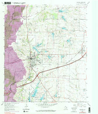
1963 Map of Rockwall
USGS Topo · Published 1973About this map
Rockwall serves as the hub of this North Texas landscape, where the Missouri-Kansas-Texas railroad and a growing highway network intersect. The terrain is defined by the broad floodplain of the East Fork Trinity River, showing areas subject to controlled inundation that would later form part of the regional reservoir system. Small agrarian footprints like Glen Hill and the Zollner Ranch persist alongside localized industry, including a Claypit and several quarries near Squabble Creek.
Find a feature on this map
41 named features on this map. Tap any name to fly to it.
Don’t see what you’re looking for? This feature index may not catch every label — zoom into the map to look around manually.
Map Details
Editions of this 1963 Rockwall Map
4 editions found
Other maps of this area

1891 · Dallas
USGS Topo · 1:125,000

1893 · Dallas
USGS Topo · 1:125,000

1912 · Rockwall
USGS Topo · 1:31,680

1919 · Royse City
USGS Topo · 1:62,500

1924 · Farmersville 3-c
USGS Topo · 1:48,000

1924 · Mc Kinney 4-d
USGS Topo · 1:48,000

1929 · McKinney
USGS Topo · 1:62,500

1930 · Farmersville
USGS Topo · 1:62,500

1954 · Dallas
USGS Topo · 1:250,000

1954 · Sherman
USGS Topo · 1:250,000