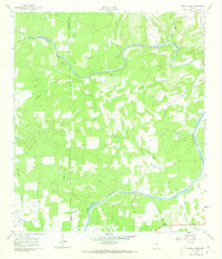
1961 Map of Rocky Creek
USGS Topo · Published 1973About this map
The Pedernales River carves through the Texas Hill Country at the border of Gillespie and Blanco Counties, creating a landscape defined by seasonal drainages and cattle country. During the early 1960s, this area remained largely rural, anchored by small family cemeteries such as the Post Oak Cem and another Cemetery to the south. The hydrology is complex, with North Grape Creek and its many tributaries, including Dry Hollow Creek and Spring Branch, feeding the primary river system. Local industry is represented by small-scale resource extraction, including a Quarry and scattered Gravel Pits. A notable modern addition to this ranching landscape is the Landing Strip in the southwest corner, while traditional movement is traced along the banks of Post Oak Creek and Iron Rock Creek.
Find a feature on this map
18 named features on this map. Tap any name to fly to it.
Don’t see what you’re looking for? This feature index may not catch every label — zoom into the map to look around manually.
Map Details
Editions of this 1961 Rocky Creek Map
2 editions found
Other maps of this area

1887 · Blanco
USGS Topo · 1:125,000

1894 · Fredericksburg
USGS Topo · 1:125,000

1894 · Blanco
USGS Topo · 1:125,000

1954 · Llano
USGS Topo · 1:250,000

1955 · Llano
USGS Topo · 1:250,000

1956 · Llano
USGS Topo · 1:250,000

1961 · Stonewall
USGS Topo · 1:24,000

1961 · Hye
USGS Topo · 1:24,000

1961 · Cave Creek School
USGS Topo · 1:24,000

1961 · Rocky Creek
USGS Topo · 1:24,000