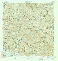
1942 Map of Rosario
USGS Topo · Published 1942About this map
The agricultural heart of western Puerto Rico is meticulously detailed in this early 1940s survey, overseen by Commissioner Sergio Cuevas. Numerous family-owned estates define the landscape, including Hacienda Juanita, Hacienda Corcega, and Hacienda Esperanza, illustrating the region's historical reliance on coffee and sugar production. The terrain rises toward the Bosque Insular de Maricao in the east, while the village of Rosario serves as a central hub near the Rio Rosario. Religious life is well-documented through scattered chapels such as Capilla de Santa Ana and the Iglesia de San Jose. Of particular note is the Hospital de Tuberculosis located in the western sector, marking a significant public health landmark for the era. The map also traces an extensive network of footpaths or Vereda and communication lines indicated as Linea and Transmision, connecting remote highlands to more established settlements.
Find a feature on this map
86 named features on this map. Tap any name to fly to it.
Don’t see what you’re looking for? This feature index may not catch every label — zoom into the map to look around manually.
Map Details
Editions of this 1942 Rosario Map
3 editions found

Other maps of this area

1935 · Puerto Real
USGS Topo · 1:25,000

1937 · San German
USGS Topo · 1:25,000

1937 · Sabana Grande
USGS Topo · 1:25,000

1937 · Puerto Real
USGS Topo · 1:25,000

1938 · Alto Sano
USGS Topo · 1:20,000

1938 · San Sebastian
USGS Topo · 1:20,000

1939 · Mayaguez
USGS Topo · 1:30,000

1941 · Rincon
USGS Topo · 1:30,000

1941 · San German
USGS Topo · 1:30,000

1941 · Puerto Real
USGS Topo · 1:30,000
Featured Places
- Sector Los Martinel, Las Marías
- Urb. Mansiones La Monserrate, Hormigueros
- Sector Coquí, Mayagüez
- Sector Punto Cubano, Hormigueros
- Sector Leclerc, Mayagüez