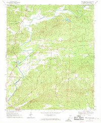
1967 Map of Ross Mountain
USGS Topo · Published 1969About this map
Ross Mountain dominates the central topography of this Cleburne County region, where the Tallapoosa River winds through the northern and western reaches of the landscape. During the late 1960s, this area was characterized by a rural network of small communities and crossroads anchors such as Arbacoochee and Belltown. The presence of numerous country churches, including New Harmony Ch, Greens Chapel, and Beason Grove Ch, indicates a deeply rooted social fabric centered around these local congregations.
Find a feature on this map
29 named features on this map. Tap any name to fly to it.
Don’t see what you’re looking for? This feature index may not catch every label — zoom into the map to look around manually.
Map Details
Editions of this 1967 Ross Mountain Map
3 editions found
Other maps of this area

1889 · Tallapoosa
USGS Topo · 1:125,000

1891 · Ashland
USGS Topo · 1:125,000

1892 · Tallapoosa
USGS Topo · 1:125,000

1897 · Tallapoosa
USGS Topo · 1:125,000

1899 · Wedowee
USGS Topo · 1:125,000

1900 · Anniston
USGS Topo · 1:125,000

1902 · Wedowee
USGS Topo · 1:125,000

1953 · Atlanta
USGS Topo · 1:250,000

1954 · Choccolocco
USGS Topo · 1:24,000

1957 · Atlanta
USGS Topo · 1:250,000