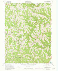
1960 Map of Round Bottom
USGS Topo · Published 1972About this map
Winklers Mill sits along the Watkins Fork of Sunfish Creek, surrounded by the deeply dissected topography of Monroe County. This 1960 field survey reveals a landscape where ridge-top agriculture and valley industry coexist, evidenced by the numerous Oil Wells and Gas Well sites scattered between Sykes Ridge and Sardis Ridge. The eastern boundary is defined by the Ohio River, where Lock 15 manages the waterway near the riverfront settlements of Hannibal and Sardis.
Find a feature on this map
89 named features on this map. Tap any name to fly to it.
Don’t see what you’re looking for? This feature index may not catch every label — zoom into the map to look around manually.
Map Details
Editions of this 1960 Round Bottom Map
4 editions found
Other maps of this area

1905 · Clarington
USGS Topo · 1:62,500

1905 · New Matamoras
USGS Topo · 1:62,500

1905 · Woodsfield
USGS Topo · 1:62,500

1906 · New Martinsville
USGS Topo · 1:62,500

1924 · New Martinsville
USGS Topo · 1:62,500

1924 · New Matamoras
USGS Topo · 1:62,500

1926 · New Martinsville
USGS Topo · 1:62,500

1926 · New Matamoras
USGS Topo · 1:62,500

1935 · Clarington
USGS Topo · 1:62,500

1940 · Clarington
USGS Topo · 1:62,500