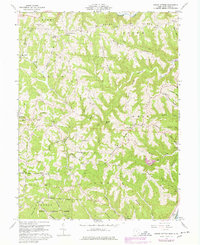
1960 Map of Round Bottom
USGS Topo · Published 1978About this map
Sunfish Creek winds through the northern portion of this landscape, which is defined by an intricate network of narrow ridges and hollows in Monroe County. The settlement patterns follow these high points, with roads and homesteads tracing features like Mule Ridge, Harmon Ridge, and Sardis Ridge. Along the Ohio River, the communities of Hannibal and Sardis serve as the primary riverfront hubs. This survey reveals a high density of rural institutions, particularly cemeteries and churches such as St James Ch and the McIntire Cem, indicating a long-established community structure deeply tied to family and local history.
Find a feature on this map
97 named features on this map. Tap any name to fly to it.
Don’t see what you’re looking for? This feature index may not catch every label — zoom into the map to look around manually.
Map Details
Editions of this 1960 Round Bottom Map
4 editions found
Other maps of this area

1905 · Clarington
USGS Topo · 1:62,500

1905 · New Matamoras
USGS Topo · 1:62,500

1905 · Woodsfield
USGS Topo · 1:62,500

1906 · New Martinsville
USGS Topo · 1:62,500

1924 · New Martinsville
USGS Topo · 1:62,500

1924 · New Matamoras
USGS Topo · 1:62,500

1926 · New Martinsville
USGS Topo · 1:62,500

1926 · New Matamoras
USGS Topo · 1:62,500

1935 · Clarington
USGS Topo · 1:62,500

1940 · Clarington
USGS Topo · 1:62,500