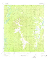
1952 Map of Ruby A-2
USGS Topo · Published 1974About this map
Nowitna River meanders through the northwest corner of this sub-arctic landscape, its complex oxbows and marshy lowlands contrasting with the rising elevations of the interior. The interior topography is defined by the headwaters of several drainage systems, including Mastodon Creek and the eastward-flowing American Creek. Based on 1952 aerial photography, this survey by the Bureau of Land Management and the Geological Survey documents the unpopulated wilderness of central Alaska before later development or designation changes. A distinctive high point is marked at VABM 2497 Solukna, serving as a primary geodetic reference in an area otherwise defined by the serpentine path of the Telsitna River along the eastern boundary.
Find a feature on this map
10 named features on this map. Tap any name to fly to it.
Don’t see what you’re looking for? This feature index may not catch every label — zoom into the map to look around manually.
Map Details
Editions of this 1952 Ruby A-2 Map
2 editions found
Other maps of this area

1950 · Medfra
USGS Topo · 1:250,000

1951 · Ruby
USGS Topo · 1:250,000

1952 · Ruby A-2
USGS Topo · 1:63,360

1952 · Ruby B-1
USGS Topo · 1:63,360

1952 · Ruby B-2
USGS Topo · 1:63,360

1952 · Ruby A-3
USGS Topo · 1:63,360

1952 · Ruby A-1
USGS Topo · 1:63,360

1952 · Ruby B-3
USGS Topo · 1:63,360

1952 · Ruby
USGS Topo · 1:250,000
1953 · Ruby B-3
USGS Topo · 1:63,360