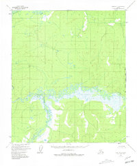
1952 Map of Ruby B-1
USGS Topo · Published 1981About this map
Titna River meanders across this interior landscape, defined by a broad expanse of wetlands and complex oxbow formations. In this 1952 study, the river serves as the primary geographical anchor, joined from the south by the Telzitna River. The presence of small structures labeled simply as Cabins along the northern bank of the Titna River points to the seasonal subsistence and trapping patterns characteristic of the Yukon-Koyukuk region. To the far north, the Big Mud River clips the corner of the quadrangle, while the southeast is drained by Baker Creek. This map preserves the remote character of the territory along the Kateel River Meridian before later developments, showing a wilderness accessible primarily by water and traditional overland routes.
Find a feature on this map
6 named features on this map. Tap any name to fly to it.
Don’t see what you’re looking for? This feature index may not catch every label — zoom into the map to look around manually.
Map Details
Editions of this 1952 Ruby B-1 Map
3 editions found
Other maps of this area

1948 · Kantishna River
USGS Topo · 1:250,000

1951 · Kantishna River
USGS Topo · 1:250,000

1951 · Ruby
USGS Topo · 1:250,000

1952 · Ruby A-2
USGS Topo · 1:63,360

1952 · Ruby B-1
USGS Topo · 1:63,360

1952 · Ruby B-2
USGS Topo · 1:63,360

1952 · Ruby A-1
USGS Topo · 1:63,360

1952 · Ruby C-1
USGS Topo · 1:63,360

1952 · Kantishna River C-6
USGS Topo · 1:63,360

1952 · Ruby C-2
USGS Topo · 1:63,360