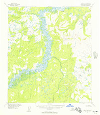
1952 Map of Ruby B-4
USGS Topo · Published 1957About this map
The Sulatna River dominates this interior Alaskan landscape, its tightly winding meanders creating a complex network of wetlands and oxbow lakes as it flows through the valley. This mid-century survey, based on 1952 aerial photography, captures a region defined by its drainage systems and the prominent Monzonite Hills that rise to the east. The terrain is marked by a series of significant tributaries, including Bonanza Creek, Little Bonanza Creek, and Cottonwood Creek, which suggest the historical importance of waterway access for travel and prospecting in this part of the Yukon-Koyukuk region. A solitary Trail provides the only evidence of overland passage, cutting through the northwestern portion of the sheet near Flint Creek. The geography here, from the elevation of VABM 1251 Flint to the low-lying basin of the river, illustrates the topographical character of the Ruby quadrangle during an era of systematic geological mapping.
Find a feature on this map
12 named features on this map. Tap any name to fly to it.
Don’t see what you’re looking for? This feature index may not catch every label — zoom into the map to look around manually.
Map Details
Editions of this 1952 Ruby B-4 Map
3 editions found
Other maps of this area

1951 · Ruby
USGS Topo · 1:250,000

1952 · Ruby A-3
USGS Topo · 1:63,360

1952 · Ruby A-4
USGS Topo · 1:63,360

1952 · Ruby C-3
USGS Topo · 1:63,360

1952 · Ruby B-4
USGS Topo · 1:63,360

1952 · Ruby C-5
USGS Topo · 1:63,360

1952 · Ruby B-3
USGS Topo · 1:63,360

1952 · Ruby B-5
USGS Topo · 1:63,360

1952 · Ruby A-5
USGS Topo · 1:63,360

1952 · Ruby C-4
USGS Topo · 1:63,360